2015 Annual Science Report
 SETI Institute
Reporting | JAN 2015 – DEC 2015
SETI Institute
Reporting | JAN 2015 – DEC 2015
Remote Sensing of Ancient Habitable Environments on Mars
Project Summary
We are investigating variations in clay chemistry on Mars using CRISM, HiRISE and HRSC imagery. Initial work is focusing on the Mawrth Vallis region where aqueous outcrops are known to be varied and expansive. The mineralogy of these aqueous outcrops are under study in order to characterize and document changes in the environmental chemistry over time.
Project Progress
Recently developed CRISM (Compact Reconnaissance Imaging Spectrometers for Mars) parameters and newly available DTMs (Digial Terrain Models) are enabling refined characterization of the mineralogy at Mawrth Vallis. Stratigraphy is mapped using HRSC (High Resolution Stereo Camera) DTMs across 100s of kms and, using HiRISE (High Resolution Imaging Science Experiment) DTMs, across 100s of meters. Transitions in mineralogic units (i.e., formations) were characterized using spectral properties and surface morphology. The observations point to an ancient wet and warm geologic record that formed a thick nontronite unit, a period of wet/dry cycling to create acid alteration, followed by leaching or pedogenesis to result in Al-phyllosilicates, and finally a drier, colder climate that left the altered ash in the form of nano-phase aluminosilicates, rather than crystalline clays.
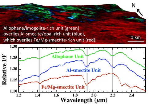
Early in 2015, we characterized a newly discovered nanophase aluminosilicate unit present at the top of the clay stratigraphy at Mawrth Vallis. This study coordinated CRISM and TES (Thermal Emission Spectrometer) spectra in order to benefit from mineral detections using both the VNIR (CRISM) and mid-IR regions (TES). The presence of materials such as allophase and imogolite at the top of the clay profile implies a change in environment at Mawrth Vallis about 3.9-4 Ga from one that was warm and wet, where water was ponding and smectite clays formed, to a different (perhaps colder and drier) environment where the water/rock ratio was lower and alteration halted with the nanophase aluminosilicates. A diagram of this newly defined allophane/imogolite unit above Al-phyllosilicates and nontronite is shown in Figure 1.
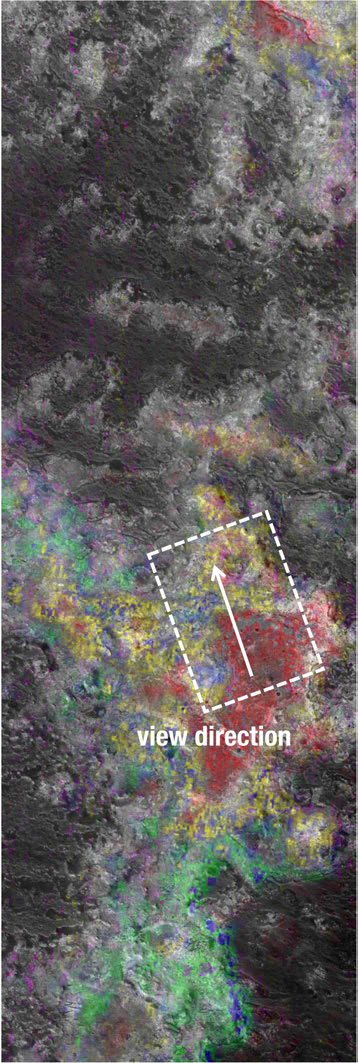
Later in 2015, additional aqueous alteration units in the Mawrth Vallis region were characterized. We investigated acid alteration at Mawrth Vallis using newly available MTR3 images, newly developed mineral parameters, and newly designed band detection algorithms. We discovered that the products of acid alteration are not formed in small pockets within the Al-phyllosilicate unit as we had previously thought, but that these materials appear to form in a discreet geologic unit below the Al-phyllosilicates. We were also able to better constrain and characterize the Fe2+-clay unit using the new CRISM images and we found this to be a separate unit below the acid alteration zone and above the thick nontronite unit. We were able to discern the stratigraphy of these 5 aqueous alteration units at Mawrth Vallis using 3D views of CRISM images over MOLA (Mars Orbiter Laser Altimeter) topography, using CRISM parameters over 3D CTX/HRSC mosaics, and using CRISM parameters over 3D HiRISE images. Views of these recently defined 5 aqueous units at Mawrth Vallis are illustrated in Figures 2-3.


-
PROJECT INVESTIGATORS:
-
PROJECT MEMBERS:
Elizabeth Rampe
Co-Investigator
James Wray
Co-Investigator
Christoph Gross
Collaborator
Mairo Parente
Collaborator
-
RELATED OBJECTIVES:
Objective 2.1
Mars exploration.
