2014 Annual Science Report
 University of Wisconsin
Reporting | SEP 2013 – DEC 2014
University of Wisconsin
Reporting | SEP 2013 – DEC 2014
Project 1A: Field Analog Geology and Astrobiology in Support of Mars Exploration
Project Summary
We report on preliminary results obtained from the field research campaign exploring the area around the Mars Desert Research Station (MDRS) in Utah (Canyonlands area) in February/March 2012. This region has been previously investigated and characterized as geomorphological and geochemical similar to Mars. Soil and rock samples were collected within two formations of a single geological units, the Brushy Basin and Tununk Shale Member. The objective of this research was to characterize samples from plain, cliff and canyon locations using different analysis techniques including Fourier Transform Infra-Red Spectroscopy (FTIR), X-ray diffraction studies (XRD) and elemental composition surface and morphology (SEM-EDX) in order to determine the sample mineralogy and its variability within the geological unit. The analysis of the organic content of the collected samples (extraction of amino acids) is currently underway. Our aim is to compare data from different formations, topographical units, and specific locations in this Utah desert region in order to determine the variations in chemical and physical properties.
Project Progress
The geology around the MDRS is comprised of Late Jurassic and Cretaceous deposits. The Jurassic deposits around MDRS are represented by the Morrison Formation and the Cretaceous deposits by the Dakota Sandstone and the Mancos Shale Formation. Ten samples were collected in the Morrison Formation (I1-I7) and the Mancos Shale Formation (I8-I10) at depths of 0, 25 and 50cm. For each subregion sample locations in the plain, cliff and canyon were selected. Samples have been analysed by X-ray diffraction, Fourier Transform Infrared Spectroscopy (FTIR) using an Excalibur FTS-4000 Infra-Red spectrometer (BioRad) in the range of 4000–500 cm-1 and sample morphologies were determined using a Quanta 650 FEG Field Emission Scanning Electron Microscope (FEG-SEM) with a nominal spatial resolution of around 3nm. Elemental analyses (C, H, N) was performed with a Perkin-Elmer series II CHNS/O analyzer 2400. The elemental analysis indicates low values for carbon and very low values for nitrogen elements. However, samples from the Tununk Shale (Mancos Shale Formation) are by a factor 2-4 more C-rich compared to the samples from the Brushy Basin (Morrison Formation), see Figure 1.

We are currently completing a thorough analysis of all band signatures in the infrared spectra. Figure 2 displays a preliminary FTIR mineralogical analysis of all samples according to topography. Organic matter can’t be detected using FTIR only (organic signatures are below the detection limit) but we are currently investigating the concentrations of amino acids in the soil using specific extraction methods.
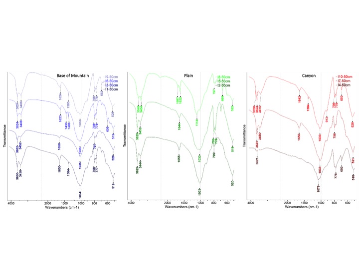
A majority of the samples from both formations are clay-rich. However, no perfect agreement can be achieved using FTIR and XRD data. In the latter technique the non-clay fraction is higher in samples from the Tununk Shale. The attempt to reconcile FTIR and XRD data indicates the limitations of both techniques and/or heterogeneities within the samples. The completed data set, including the organic analysis, will allow us to compare data from the interesting Morrison and Tununk Shale Formations. The Late Jurassic Morrison formation is mostly comprised of (continental) floodplain and fluvial deposits and characterized by (smectite) clay and mudstone deposits, whereas the Mancos Shale consists of dark grey to black shaley plates which have been deposited in a deep sea environment. In combination with the data on organic compounds we will correlate data from the different topographical units and determine the variations in chemical and physical properties among the individual sample locations. The main objective of this campaign was to assist the interpretation of data from Mars orbiters, the Mars Science Laboratory (MSL) data aboard Curiosity and in preparation for future Mars missions.
Publications
-
Aerts, J., Röling, W., Elsaesser, A., & Ehrenfreund, P. (2014). Biota and Biomolecules in Extreme Environments on Earth: Implications for Life Detection on Mars. Life, 4(4), 535–565. doi:10.3390/life4040535
-
Direito, S. O. L., Zaura, E., Little, M., Ehrenfreund, P., & Röling, W. F. M. (2014). Systematic evaluation of bias in microbial community profiles induced by whole genome amplification. Environmental Microbiology, 16(3), 643–657. doi:10.1111/1462-2920.12365
-
Frick, A., Mogul, R., Stabekis, P., Conley, C. A., & Ehrenfreund, P. (2014). Overview of current capabilities and research and technology developments for planetary protection. Advances in Space Research, 54(2), 221–240. doi:10.1016/j.asr.2014.02.016
-
PROJECT INVESTIGATORS:
-
PROJECT MEMBERS:
Pascale Ehrenfreund
Project Investigator
Andreas Elsaesser
Co-Investigator
Joost Aerts
Collaborator
-
RELATED OBJECTIVES:
Objective 2.1
Mars exploration.
Objective 5.3
Biochemical adaptation to extreme environments