2015 Annual Science Report
 SETI Institute
Reporting | JAN 2015 – DEC 2015
Understanding Ancient Aqueous Environments on Mars
Project Summary
Project 1: The goal of this project is to characterize ancient aqueous environments on Mars using Digital Terrain Model (DTM) analysis and mapping to understand the potential environments for past habitability. These include fluvial environments with morphological evidence for ponding, associated with hydrothermal systems and multiple episodes of surface and near surface flow in channelized systems. We will determine sediment and eroded volumes of fluvial landforms from DTM analysis and use transport equations and terrestrial analogs to understand likely discharges and flow durations.
Project Progress
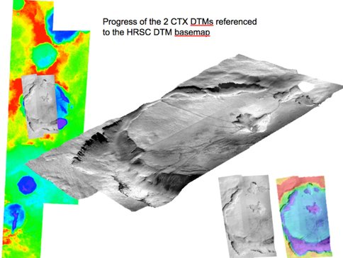
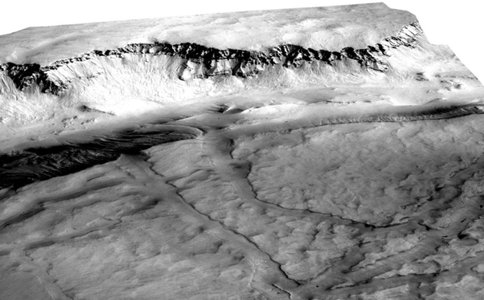
We have installed the NASA Ames Stereo Pipeline (ASP) on our workstation. ASP is a suite of automated, open source, photogrammetry software designed for processing planetary and terrestrial orbital imagery (Moratto et al., 2010). This tool set produces cartographic products, including digital elevation or digital terrain models (DEMs, DTMs), ortho-projected imagery, and 3D models. During our first year, we have produced five Mars Reconnaissance Orbiter’s (MRO) Context Camera (CTX) and one Mars Express High Resolution Stereo Camera (HRSC) DTMs, including one of Candor Chasma, two of central and western Asimov crater, three of Navua Valles, and one HRSC DTM of Asimov crater, Mars. We also mosaicked two CTX DTMs of western and central Asimov crater. (Figure 1 and 2).
We have also explored producing MRO High-Resolution Imaging Science Experiment (HiRISE) DTMs via the ASP, but have determined that HiRISE DTMs would have better accuracy if generated using BAE Systems’ commercial digital photogrammetry software program known as SOCET SET. Therefore, Project Co-I Glines participated in USGS Flagstaff’s SOCET SET training workshop in June 2015, and we now can produce HiRISE DTMs using SETI Institute’s SOCET SET workstation. Alternatively, we can also generate CTX and HRSC DTMs with SOCET SET. We are able to reference both HiRISE and CTX DTMs to the Mars Orbiter Laser Altimeter (MOLA) data. Project Co-Is Dr. Henrik Hargitai and Ms. Natalie Glines also participated in the Geographical Information Systems (GIS) computerized mapping and analysis software training workshop at USGS Flagstaff.
Project Collaborator Hargitai (NASA senior post-doctoral researcher) mapped the drainage systems and the terrain units in the Navua Valles region using ARC GIS. Crater diameters and locations were recorded using CraterTools and size-frequency distributions were analyzed using CraterStats II. Our preliminary studies indicate that there were at least several fluvial events in this region spanning from the Noachian to the late Amazonian. These events involved multiple, prolonged duration fluvial flow and larger flood events within the drainage systems region. The Navua Valles region is an area of astrobiological interest because it is situated downstream of both Hadriaca Patera and Tyrrhena Patera and was likely connected to the long-lived volcanic hydrothermal systems associated with these two volcanoes. Our work implies that not only did ground-water outflow catastrophically from the flanks of the volcano Hadriaca Patera to form the adjacent Dao, Niger, Harmakhis and Reull Valles, but that there were also multiple prolonged flow events of lower discharges emanating from the flanks of these volcanoes throughout Mars’ history. Both flows from Navua Valles and these outflow-like channels emptied into Hellas Basin. Preliminary estimates for flow discharges in Navua Valles range from 10^2 to 10^4 m^3/sec. We have presented our preliminary geologic and drainage maps in a poster at the 2015 Fall American Geophysical Meeting.
Gulick and Glines collaborated with Project Collaborator Alexis Rodriguez (former NPP senior post-doctoral researcher) on several papers this year related to understanding the sources and the role of extensive ground-water outflows in forming the outflow channels throughout Mars fluvial history. These papers also reflected on sites within these outflow systems that may have provided potentially habitable environments on Mars (Rodriguez et al 12015 a, b, c). Gulick and Rodriguez also collaborated with other planetary scientists in writing a review paper (Baker et al., 2015) on Fluvial Geomorphology on Earth-like planetary surfaces. This paper included a review of fluvial processes at all spatial scales on Mars and its implications for potentially habitable environments.
Publications
-
Baker, V. R., Hamilton, C. W., Burr, D. M., Gulick, V. C., Komatsu, G., Luo, W., … Rodriguez, J. A. P. (2015). Fluvial geomorphology on Earth-like planetary surfaces: A review. Geomorphology, 245, 149–182. doi:10.1016/j.geomorph.2015.05.002
-
Rodriguez, J. A. P., Kargel, J. S., Baker, V. R., Gulick, V. C., Berman, D. C., Fairén, A. G., … Glines, N. (2015). Erratum: Martian outflow channels: How did their source aquifers form, and why did they drain so rapidly?. Scientific Reports, 5, 15092. doi:10.1038/srep15092
-
Rodriguez, J. A. P., Kargel, J. S., Baker, V. R., Gulick, V. C., Berman, D. C., Fairén, A. G., … Glines, N. (2015). Martian outflow channels: How did their source aquifers form, and why did they drain so rapidly?. Scientific Reports, 5, 13404. doi:10.1038/srep13404
-
Rodriguez, J. A. P., Platz, T., Gulick, V., Baker, V. R., Fairén, A. G., Kargel, J., … Glines, N. (2015). Did the martian outflow channels mostly form during the Amazonian Period?. Icarus, 257, 387–395. doi:10.1016/j.icarus.2015.04.024
-
PROJECT INVESTIGATORS:
-
PROJECT MEMBERS:
Natalie Glines
Co-Investigator
Henrik Hargitai
Collaborator
Alexis Rodriguez
Collaborator
-
RELATED OBJECTIVES:
Objective 1.1
Formation and evolution of habitable planets.
Objective 2.1
Mars exploration.
Objective 7.1
Biosignatures to be sought in Solar System materials


